| Acronym | Project name | Duration | Contract | Funding |
| RAdCor | Remote sensing Adjacency Correction | 2 years | SR/00/406 | BELSPO |
Inland water satellite images are strongly impacted by adjacency effects, and retrieval of water reflectance and derived parameters are adversely affected, especially for small and narrow water bodies. The adjacency effects are most pronounced in spectral regions with high contrast between land and water, typically from the Red Edge to Near-Infrared (NIR) wavelengths, where large water absorption typically results in low water reflectance. Adjacency effects may dominate the signal in these bands, and hence will directly impact retrievals from algorithms using Red Edge and NIR bands, e.g. the retrieval of chlorophyll a (e.g. Gons et al., 1999) and turbidity (e.g. Nechad et al., 2009). Vegetation adjacency may introduce false chlorophyll a like signals (due to the strong Red Edge of vegetation), with a seasonal effect in the mid latitudes. Bare soil and vegetation both impact strongly the retrieval of turbidity using the NIR bands. Concretely, for these water bodies, the Red Edge and NIR remote sensing data are practically unusable without a proper adjacency correction.
In RAdCor, we propose to improve the accuracy of remote sensing measurements by developing a generic method for adjacency correction. The objective is to develop a physics-based adjacency correction for both land and water to extend the Dark Spectrum Fitting method and the ACOLITE software to improve satellite remote sensing in high contrast environments under turbid atmospheres.
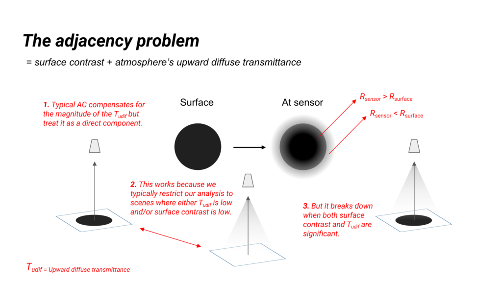
To have an accurate adjacency correction, it is necessary to account for the spatial distribution of the diffusely transmitted signal through the atmosphere and to relax the assumption of low spatial contrast in the surface reflectance. These are complex and computationally intensive procedures, typically not featured in atmospheric correction (AC) methods.
The RAdCor model will be a physically-based method, i.e. incorporating realistic spectral atmospheric point spread functions (APSF) to account for the wavelength-dependent spatial distribution of the diffuse transmittance and surface reflectance. This approach would allow to apply adjacency correction for nadir (e.g. Landsat and Sentinel-2), off-nadir observations (e.g. Pléiades and Skysats) and variable height imagery (airborne/APEX to orbital sensors).
Relaxing the assumption of low spatial contrast is the most challenging aspect from practical (i.e. working within a given image extent) and computational perspectives (i.e. for metre scale sensors many neighbouring pixels need to be evaluated to account for typical APSF).
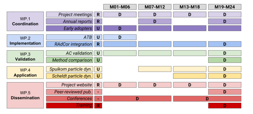
Structure and timeline