
About
High-quality satellite-based ocean colour products can provide valuable support and insights in management and monitoring of coastal ecosystems. Today’s availability of Earth Observation (EO) data is unprecedented including traditional medium resolution ocean colour systems -S3plus- (e.g. MODIS-AQUA, Sentinel-3/OLCI), high resolution land sensors –S2plus- (e.g. Sentinel-2/MSI, Landsat-8/OLI, Pleiades) and geostationary satellites –GEO- (e.g. SEVIRI). Each of these sensors offers specific advantages in terms of spatial, temporal or radiometric characteristics.
Within the Multi-Sync project (SR/00/359/, Belspo - Stereo 3 programme, innovation project) we develop advanced ocean colour products (i.e. remote sensing reflectance, turbidity, and chlorophyll a concentration) through synergetic use of multi-scale EO data taking advantage of spectral characteristics of S3plus sensors, the high spatial resolution of S2plus sensors and the high temporal resolution of GEO sensors.
To reach this main objective the following scientific objectives are defined:
- Develop an error propagation model to track the uncertainties associated with atmospheric correction, inversion algorithms and
spectral/spatial/temporal characteristics of the sensors through the ocean colour product generation process?
- Develop a multi-scale DINEOF approach to reconstruct missing data using empirical orthogonal functions (EOF), reduce noise and
exploit spatio-temporal coherency by joining several spatial and temporal resolutions in a 2-step approach:
- Adaptation of DINEOF to high spatial resolution satellite data
- Develop a multi-scale DINEOF to work with datasets with different spatial and temporal resolutions and study
the capacity of DINEOF to extract multi-scale information through the integration of S3plus, S2plus and GEO datasets
- Adaptation of DINEOF to high spatial resolution satellite data
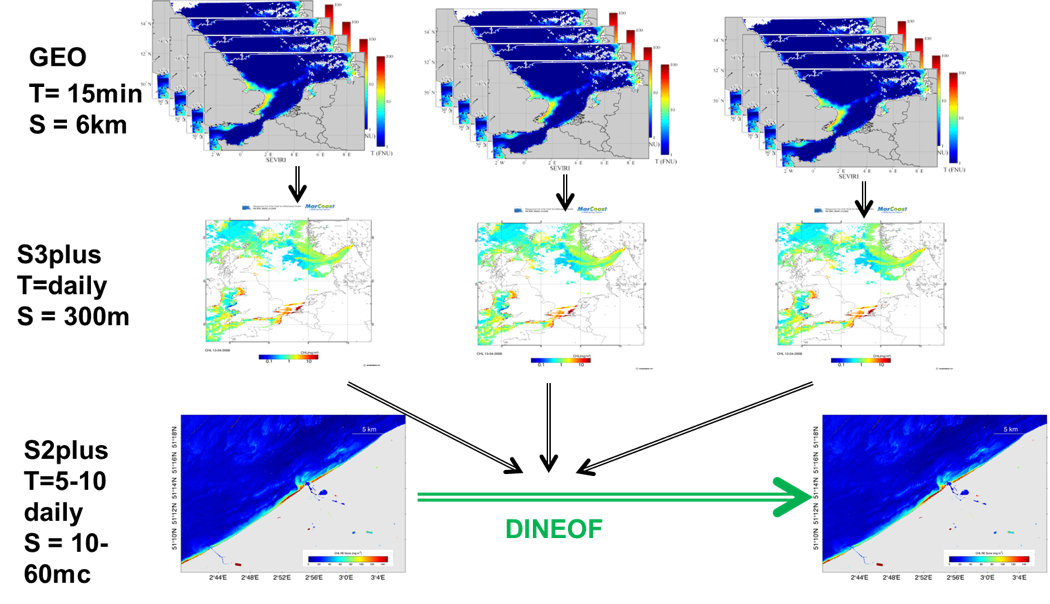 Figure:
Schematic overview of the integration of three different satellite data sources, each with their own temporal frequency (T) and
spatial resolution (S) using a multi-scale DINEOF gap filling approach.
(GEO=geo-stationary sensors, S3plus = moderate resolution sensors, S2plus = high resolution sensors)
Figure:
Schematic overview of the integration of three different satellite data sources, each with their own temporal frequency (T) and
spatial resolution (S) using a multi-scale DINEOF gap filling approach.
(GEO=geo-stationary sensors, S3plus = moderate resolution sensors, S2plus = high resolution sensors)