NOOS-Drift is a transnational multi-models ensemble system to assess and improve drift forecast accuracy in the European North West Continental Shelf Seas.
The NOOS-Drift service aims at providing end-users such as maritime authorities and coastguards stations from the countries bordering the North West Shelf not only with drift trajectory forecasts but also with information on the accuracy of the forecast. Designed as a one stop shop service, registered users can activate the service on-demand either via a simple web form or a machine to machine API. Within 30 minutes after the activation, the users can visualize, analyze and download the results of the multi-model analysis.
To our knowledge, the operation of a distributed, transnational multi-models ensemble system allowing to assess the quality of drift simulations is a world premiere.
NOOS-Drift is developed and operated by
Drift models are multi-purpose tools that forecast the drift trajectory of any objects, substances or resources drifting at the sea surface or in the water column. Typically activated several hundreds to several thousands of times per year and per country, drift models are among the most valuable tools in the day to day management of the coastal and marine environment, marine resources and maritime safety.
Drift models are so important that each country bordering the NWS operates at least one drift forecasting service. These services are all based on ‘in-house’ or commercial Lagrangian drift models that compute the displacement of a cloud of Lagrangian particles under the action of the wind, currents and waves (also known as met-ocean forcing). Although the drift models are based on similar principles, the actual implementation largely differs from one model to another. As a consequence, their results may progressively diverge from each other - especially during storm conditions.
A question often asked by users is : “How accurate is your drift forecast?”
This is a tricky question since the accuracy of a drift forecast depends on
Modelers sometimes answer this question by referring to some past validation experiences, but this reply only provides limited information on the situation at stake.
Another way to estimate uncertainty is to compare an ensemble of drift forecast simulations of the same drift event, produced by different models and/or different met-ocean forcings. NOOS-Drift privileged this second approach, assuming that the multi-models ensemble spread is likely the best proxy to estimate the drift forecast uncertainty.
At every activation of the NOOS-Drift service, each drift model service provider connected to the NOOS-Drift central server is expected to run their own drift model with at least two different met-ocean forcings:
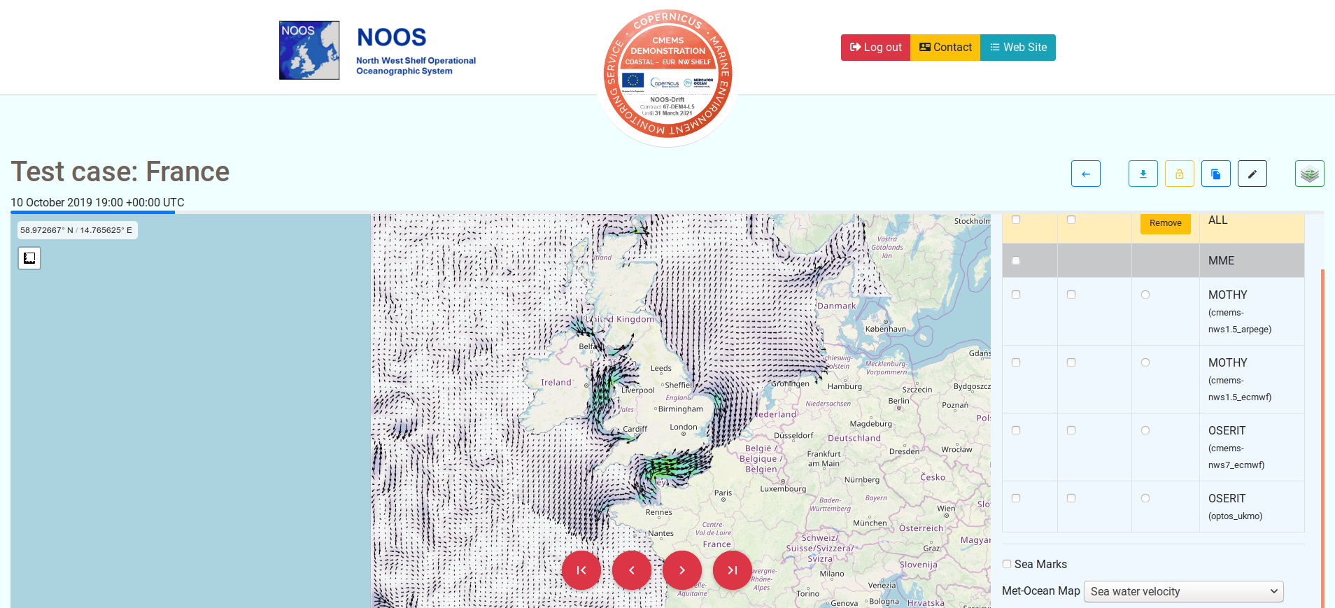
In order to identify possible outliers, the different drift trajectories are clustered as a function of their relative proximity and the distance traveled by the particle clouds since the start of the simulation.
The principles of the multi-model ensemble analysis is illustrated in the video tab.
The strategy to generate the NOOS-Drift ensemble relies on the following Copernicus Marine Service products:
The hourly instantaneous currents , temperature, salinity and waves parameters are directly used by the drift models as met-ocean forcing.
Some drift forecast service providers also consider extending the NOOS-Drift ensemble using other Copernicus Marine Service products coming for the IBI-region.
Before NOOS-Drift, end-users usually relied on a single drift trajectory forecast produced by their national model service provider. In case of large oil pollution at sea, they could activate several model service providers via the regional cooperation mechanism of the Bonn Agreement, but they would had to wait for several hours before receiving non-standard -hardly intercomparable- maps.
With NOOS-Drift, end-users can now activate several national model service providers in a single click and receive analysis results within 30 minutes. NOOS-Drift advantages include
This service is being conducted using E.U. Copernicus Marine Service Information.
NOOS stands for European North West Shelf Operational Oceanographic System. It is one out of the five EuroGOOS regional systems.
The animations in this video tab illustrate the principles of the NOOS-Drift multi-model ensemble analysis during storm conditions (associated with a larger spread in the met-ocean forcings).
The locations of the different particle clouds are approximated by a thin black ellipses.
These are then clustered (red ellipse) in relationship with their relative proximities.
Finally, the bold black ellipse represents the risk area, as computed by the NOOS-Drift multi-models analysis tool.
| Date | News | Document |
|---|---|---|
| 21/11/2019 | NOOS-Drift will be presented to the Cedre strategic committee members at the next Cedre technical day. |
|
| 15/11/2019 | After 18 months of developments, we are pleased to announce that NOOS-Drift is ready for operational service! |
|
| 05/11/2019 | NOOS-Drift has been presented at a cooperation meeting on HNS between France and Belgium. Delegates from Cedre, CEPPOL, FPS-Health/DG-Environment and RBINS/SURV had the opportunity to discuss the NOOS-Drift outcome. |
|
| 16/10/2019 | NOOS-Drift has been presented and fully discussed at the NOOS annual meeting 2019 |
|
| 15/10/2019 | NOOS-Drift has been mentioned at the GoMRI synthesis workshop on operational oil spill modeling, 15-17 Oct 2019, Washington, DG, USA |
|
| 23/05/2019 | The NOOS-Drift project has been presented at the CMEMS User Uptake meeting 2019 |
|
| 21/05/2019 | The NOOS-Drift project has been presented at CMEMS General Assembly 2019 |
|
| 21/11/2018 | Event lasting 19-21 November 2018, NOOS-Drift project has been presented at NOOS annual meeting, Brussels, Belgium. |
|
| 03/10/2018 | Event taking place from 22 to 23 October 2018 NOOS-Drift experts meeting, Brussels, Belgium.
|
|
| 01/06/2018 | Event 4-6 July 2018. NOOS-Drift has been presented at the 4th GEO Blue Planet conference, Toulouse, France. |
A question about NOOS-Drift? Please send an email directly to your national point of contact
or fill in our contact form.
For more information about the Copernicus Marine Service, please contact the Copernicus Marine Service Desk.